Any chance this deal can be stopped? Part of Sand Mountain to be sold to Washington county

RockChucker

Well-Known Member
Location
Highland

BLM and the Washington County Water Conservancy District have proposed a land exchange that would involve swapping 1050 acres of the Western Edge of Sand Mountain near Warner Valley with 89 acres of land in Washington near Green Springs, apparently owned by His Family/Brennan. Washington County is designated as the Facilitator of the Exchange. You can learn more at the BLM E Planning website, EplanningUi (blm.gov). You can also see the Public Scoping Notice which is attached.

We also obtained plans by the City of Washington to annex much of the acquired area into their City, which may be a significant influence in the exchange.

The proposed action just entered the Public Scoping phase, which is scheduled to conclude at 5:00 PM on April 13, 2023. UPLA, DRATS, Mayor Nanette Billings (Hurricane), BlueRibbon Coalition, and Tri State ATV have been meeting with BLM, Water Conservancy, and the City of Washington to learn more about the project.

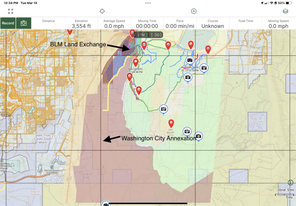
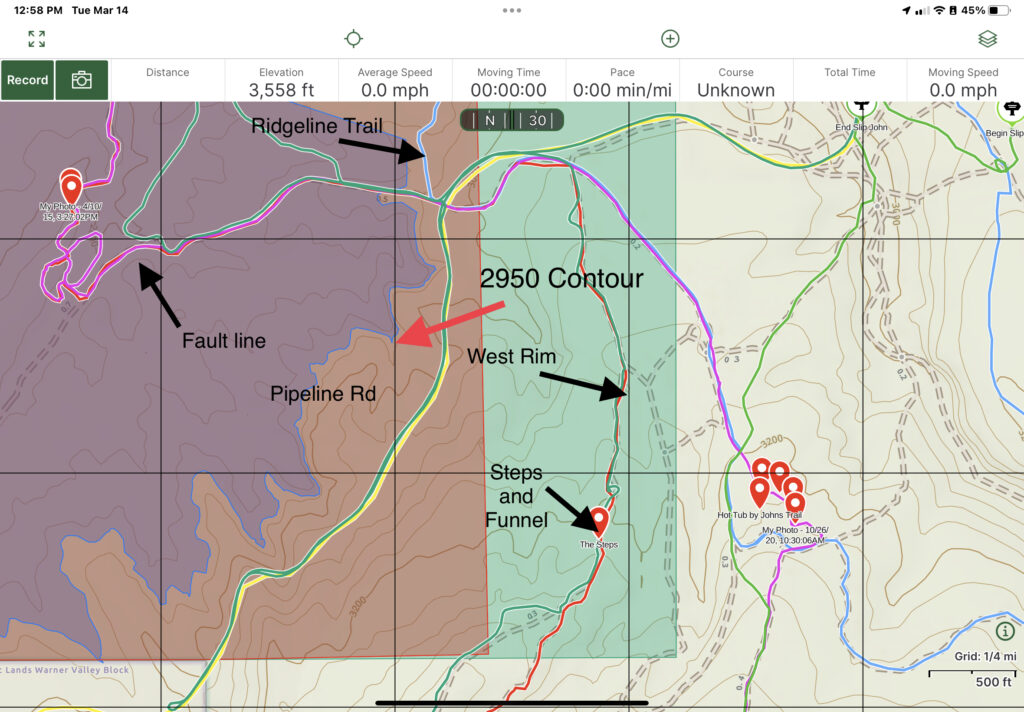
We attached a couple illustrations to show the following:

  • An Overall view of the Washington City Annexation Plan, which shows the proposed BLM Exchange areas, the new Washington City Annexation, and the proposed reservoir in the valley.
    Overall-Washington-City-Annexation-1024x712.jpg
  • In this photo, you can see the Red Outlined section was the land originally requested in October 2022, and the Green Outline shows the expanded area they added in February. The exchange and City Annexation include all of the area around the Pipeline Road and disbursed camping sites, and portions of West Rim including the Steps and The Funnel. It also shows our proposal to push the land exchange back to the 2950’ elevation right around the reservoir edge.
    2950-Contour-with-Trail-Names-1024x712.jpg


We were previously informed when the reservoir was done, we would lose the lower parts of Fault Line and Sandcutter, as well as the camping/staging area near Hwy 7, but when we learned that, we constructed the Ridgeline Trail at substantial expense to maintain access from Warner Valley.

We are extremely concerned for many reasons, including the following:

  • BLM will give up 1050 acres of Sand Mountain in exchange for 89 acres in St George
  • We will lose access to the West Rim Trail, the Restroom on Pipeline Road, the disbursed camping areas, and possibly the Ridgeline Trail we constructed to mitigate the reservoir loss.
  • We will lose staging and camping in Warner Valley
  • There has apparently been no decision about what agency would oversee recreation in the newly acquired area, but it seems likely it will become a fee area.
  • If access to Sand Mountain is impaired from Washington Dam, it will impact the load on other roads including our newly constructed Waddy’s Corral Staging area.
  • We are extremely concerned that the City of Washington will be annexing the land surrounding Pipeline Road and West Rim, and that they may permit development on top of the Rim; the views over a lake will skyrocket land values. Development would bring a whole host of issues including loss of the tremendous views from above by having buildings/homes on top of the ridge, user conflicts between residents/occupants and OHV users.
  • We only have 30 days to inform the public and submit scoping comments.
We have been working hard on this for 4 weeks to get this information. This is the part where we need you!

What we need you to do:


Attend the Public Scoping Meeting and voice your concerns. next Tuesday, March 21 from 5:00 to 7:00 at the St George Library, Forsyth Community Room B, 88 W 100 S, St George, UT 84770

We will inform the media of the event and urge them to cover it, so we urge you to drive your 4x4s and street legal machines to the meeting to show the level of concerns on this.

We have a great relationship with BLM in the St George Field Office, and it is very important that we are vocal, but respectful during the meeting. It is very likely that the crowd may exceed the capacity of the room, so please be patient. Representatives from BLM will meet with small groups of people at a time. They will also provide Comments Forms to you and help you learn how to submit them.

Following is a brief description of the Scoping process in the NEPA Review that may guide you in formulating your questions/comments for the meeting. We will have a handout for you when you enter the meeting.

The National Environmental Policy Act (NEPA) requires the Bureau of Land Management (BLM), to involve the public in the planning process and seek their input through a scoping process. Effective NEPA scoping comments for BLM should pose the questions or issues to be looked at, not provide answers.

  1. Specific information about the proposed project and its potential impacts on the environment and local communities.
  2. Identification of any alternatives to the proposed project that could mitigate or avoid potential negative impacts.
  3. Discussion of the potential cumulative effects of the proposed project in combination with other past, present, and reasonably foreseeable future actions.
  4. Analysis of potential impacts on wildlife, water resources, cultural and historic resources, and other sensitive environmental resources.
  5. Request for meaningful public participation throughout the NEPA process, including opportunities for public comment and involvement in decision-making.
  6. Request for transparency and disclosure of all relevant information, including scientific data and analysis, underlying assumptions, and potential conflicts of interest.
  7. Discussion of any potential economic impacts of the proposed project, including impacts on local jobs, property values, and tax revenue.
  8. Recommendation for monitoring and mitigation measures to minimize or address any adverse environmental impacts.
  9. Discussion of any potential long-term impacts of the proposed project on the environment and local communities.
  10. Request for BLM to consider the full range of alternatives and potential impacts, rather than limiting the analysis to a narrow set of options.
 

N-Smooth

Smooth Gang Founding Member
Location
UT
This one has been coming for years, right? We all knew it was going to happen eventually with the land swap. I don’t think there’s any amount of fighting that can be done to stop it but we have to try. At the end of the day it’s all dollar signs and we can’t beat the amount of money that developments up there will be worth. Then the owners of the multi-million dollar homes up there will hate how loud and disruptive the OHV use is and they will get the whole mountain closed.
 

N-Smooth

Smooth Gang Founding Member
Location
UT
Rich’s letter was pretty helpful to get a good idea of what he thinks are the real problems. For anybody that hasn’t written an email yet, here’s some content:


Letter from Trail Hero to BLM:

Good morning,
Thank you for reading this, it is exciting to have you as our new director and I hope to be of service to you throughout your tenure. I wanted to reach out to you for a couple reasons, all regarding the proposed Land Swap.

With the land swap:
I understand the reasoning behind the land swap on the surface level: for the city/county to pull land that cannot be utilized and stuck in the tortoise reserve to allow for more economic development within annexed city limits. While it has been said that area would not be developed, or only used for campgrounds; locals know that Brennen ("His Family Matters" the contractor the city seeks to use) has been trying to develop Sand Mountain for over 20 years. NO reason to bring in a Home developer for building an RV Park along a lake.

I am opposed to this for several reasons. First, every time a city encroaches on areas like off road parks, drag strips, etc, the home buyers eventually raise a big enough stink that the areas get shut down due to dust, noise, smells, etc. For many off-roading is a generational need, they learned to be off road advocates and enthusiasts from their parents and grandparents, while wanting to pass it down to their children and grandchildren. For me it is a MUCH larger issue, as people with special needs and veterans need motorized access to our great outdoors. Many cannot hike, bike, or ride horses, their off road vehicle is an extension of their body, it is their legs. With houses being built, the land will eventually be developed and trails will be lost, access will be lost.

Second, the area is zoned and long term agreed upon as Open Recreational. By swapping land, we are exchanging open recreation land with land that has immense restrictions that cannot be accessed by people who need motorized access. I don't think this is a reasonable exchange.

Third, I understand the need for more water and do not oppose the new reservoir as it will be used for recreation, I just oppose the idea that we will be fencing off what is now public land and limiting access to eventually build camp sites and houses.

Fourth, I as well as Desert RATS and UPLA helped pay for Ridgeline road to be put in, through the BLM Field office, with the understanding that we would be able to use the road once the dam was put in. After looking at the proposal, this may be taken away from our access as well. Additionally, the original agreement was that the public would not lose camping on the north side of the Long Valley dam, all of this is gone with the proposed land swap.

Fifth, as we lose access and egress to enter the park, it increases traffic to the other entries, making it less safe, roads more tore up, or making people create their own entrances to the park, all of which will equate to unnecessary management issues and eventual closure.

Sixth, Economic Impact. Sand Mountain has an economic impact of over $30 million annually on local and surrounding cities. Trail Hero alone makes up for $23 Million of that. Shutting down trails, access, and public lands for development does not help long term economic impact. The developer, construction companies, and some local faire will surely have financial gains, but overall, Tourism is this counties only real industry. There is little to no manufacturing, and it is known that people who go to Zion don't spend a lot of money per capita. Motorsports, per capita, is a very wealthy group of people that love spending money on hotels, fuel, food, supplies, etc. For instance, Iron Man brings in $32 Million economically, and has 6 times the amount of people that Trail Hero does... Additionally, we know that off roaders are better stewards of our public lands than most of the general public.

In summation, I fear that if the proposal moves forward, the public will lose most, if not all, of our recreational opportunities on Sand Mountain. Sand Mountain is a very unique public asset that has the ability to generate more than tax base. It has the ability to give people outdoor access which is known to be therapeutic, and the ability to experience the outdoors in a real way, with ability to travel freely, something that so little of our public lands have the option for.

Please do not move forward with the Land Swap and preserve our motorized access to our public lands.

Thank you again for your time, please feel free to call me if you have any questions of comments.

Rich Klein
Trail Hero
President
www.TheTrailHero.com
 

OrangeSkidPlate

Active Member
Location
Pocatello

If you follow the instructions in the eplanning link above, you can make comments to the field office. Believe it or not it does make a difference to the federal agencies NEPA process (I have had my NEPA decisions changed from public comments, whether they are absolutely stupid or helpful). Other than donating to groups that fight these decisions in court, commenting the next best thing. Looks like a good turn out for the scoping meeting. There have been a lot of renewable resources projects (wind farms) shut down in Idaho because of people showing up in mass to these scoping meetings and complaining. Anyways, just .02 cents coming from a BLM employee.
 

Greg

I run a tight ship... wreck
Admin

If you follow the instructions in the eplanning link above, you can make comments to the field office. Believe it or not it does make a difference to the federal agencies NEPA process (I have had my NEPA decisions changed from public comments, whether they are absolutely stupid or helpful). Other than donating to groups that fight these decisions in court, commenting the next best thing. Looks like a good turn out for the scoping meeting. There have been a lot of renewable resources projects (wind farms) shut down in Idaho because of people showing up in mass to these scoping meetings and complaining. Anyways, just .02 cents coming from a BLM employee.

Thanks for the insight!
 

RockChucker

Well-Known Member
Location
Highland

If you follow the instructions in the eplanning link above, you can make comments to the field office. Believe it or not it does make a difference to the federal agencies NEPA process (I have had my NEPA decisions changed from public comments, whether they are absolutely stupid or helpful). Other than donating to groups that fight these decisions in court, commenting the next best thing. Looks like a good turn out for the scoping meeting. There have been a lot of renewable resources projects (wind farms) shut down in Idaho because of people showing up in mass to these scoping meetings and complaining. Anyways, just .02 cents coming from a BLM employee.
Would comments at that link be more impactful than sending emails to the addresses floating around?
 

OrangeSkidPlate

Active Member
Location
Pocatello
As long as you get a comment to them, whether through the Eplanning page, mailed letter or the field office public email, it will be read and considered in the NEPA process. Also, on the Eplanning page, on the documents tab, the "EA Checklist" speaks to the rational of the field office for things like socio-economics and recreation and how those things will be effected. Comment to things like that, similar to the Trail Hero letter.

The area being trade to the BLM is within a NCA (national conservation area) so below NCA is referring to the swapped parcel. Its 89 acres of private for around 1000 acres of Public.

The socio-economic section says:
If this exchange is authorized and executed, the current BLM-managed parcel in Warner Valley is proposed for development under the St. George Area Resource Management Plan. If developed, a reservoir could result in an economic benefit to the local economy, but those benefits would likely be speculative at this time.
The Federal land is intermingled with the private lands within the Red Cliffs NCA. Many casual use visitors in the area likely already assume the parcel is federal. The non-Federal parcels, located within the NCA, are indistinguishable to the visiting public from the Federal lands; therefore, they would notice no difference in a change of ownership. Social values would not be impacted in any measurable degree from this land exchange, however the reasonably foreseeable future action of the reservoir and impacts on socioeconomics should be analyzed.

The recreation section says:
Recreational use in the NCA is limited to nonmotorized activities on designated trails. There are no designated trails on the private parcel that is proposed as part of this exchange. Therefore, there would be no impact to recreation within the NCA. The Warner Valley parcels that would leave federal ownership as part of this exchange are within the Sand Mountain Open OHV Area and have high levels of recreational use. The northernmost portion of the parcel is used as a staging area for loading and unloading vehicles and for camping. If the parcels leave federal ownership and the proposed reservoir is constructed, the recreational use in this area would be displaced and the Sand Mountain Open OHV Area would be reduced by 1,050 acres. It is anticipated that the displaced recreational users would relocate elsewhere within the Open OHV Area and would increase the use of adjacent BLM lands for camping, staging, and OHV driving. Although the Sand Mountain Open OHV Area has other staging areas and OHV routes, camping opportunities are inadequate and it would be anticipated that displaced campers would create new disturbances to the landscape. 18 companies have obtained Special Recreation permits to operate commercially on the federal parcels that are proposed as part of this exchange. If the parcels leave federal ownership and the proposed reservoir is constructed, their operations in that area would no longer be covered by their permits, thereby losing the ability to operate in that area. Each of these permits also include the entirety of the Sand Mountain Open OHV area, and it is anticipated that the businesses would still be able to operate and provide their services to the public. (the section continues to go on about a Washington County agreement about water usage, and is probably not worth posting in this format but can be read on that PDF in the documents tab)


Anyways, hopefully some of this is helpful with comments, if not just speak to how this will effect you personally or losing public land and motorized access isn't a fair trade.
 
Top