Got this in an e-mail today

Ruth Berner [rberner@fs.fed.us]; on behalf of;
comments-southern-north-carolina-nantahala-tusquitee@fs.fed.us
[FONT="]UNITED STATES DEPARTMENT OF AGRICULTURE[/FONT]
[FONT="]FOREST[/FONT][FONT="] SERVICE[/FONT]
[FONT="]NATIONAL FORESTS IN NORTH CAROLINA[/FONT]
[FONT="]NANTAHALA[/FONT][FONT="] NATIONAL FOREST[/FONT]
[FONT="]TUSQUITEE RANGER DISTRICT[/FONT]
Order Number 02-19-2009
Temporary Emergency Closure of Trails in the Upper Tellico OHV Trail and Road System
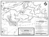
Pursuant to 36 C.F.R. § 261.50 (a) and (b) and in accordance with 36 C.F.R. § 212.52, the following acts are prohibited on the entire length of all National Forest System Trails and Roads located within the Upper Tellico OHV Trail and Road System, with exception of Trail TRUT-1/NFSR 420-1, NFSR 402 and that portion of Trail TRUT 2/NFSR 420-2 traversing from NFSR 402 to Jenks Gap, which will all remain open for use by registered, street legal motor vehicles only as further described on the Upper Tellico OHV Trail System Map. This closure is effective from April 1, 2009 until March 31, 2011, or earlier if the order is officially terminated by the Forest Supervisor.
Possession or use of a motorized vehicle on a road or trail within the Upper Tellico OHV Trail and Road system, which is closed by sign, gate or barricade. 36 C.F.R. § 261.54 (a) and (e) and 36 C.F.R. § 261.55 (a) and (b).
Pursuant to 36 C.F.R. § 261.50 (e), the following persons are exempted from this order:
- Persons with a permit from the authorized Forest Service Officer specifically authorizing an otherwise prohibited act or omission.
- Owners or lessees of land accessed by the specified trails are exempt from the prohibitions listed above to the extent necessary to gain access to their land.
- Any Federal, State or local officer or member of an organized rescue or firefighting force working in the performance of an official duty.
Executed in Asheville, North Carolina this
31st day of March, 2009
[FONT="] /s/ Marisue Hilliard [/FONT][FONT="] _[/FONT]
[FONT="] MARISUE HILLIARD[/FONT]
[FONT="] Forest Supervisor[/FONT]
[FONT="] National Forests in North Carolina[/FONT]
[FONT="]Violation of these prohibitions set forth above is punishable by a fine of not more than $5,000 for an individual and $10,000 for an organization, or imprisonment for not more than six (6) months, or both. See 16 U.S.C. 551, 18 U.S.C. 3559 and 3571.[/FONT]
DECISION MEMO
Forest Supervisor’s Orders for the
Upper Tellico Off-Highway Vehicle System
USDA Forest Service Southern Region
Nantahala National Forest
Tusquitee Ranger District
Cherokee County, North Carolina
I have decided to put into force a Forest Supervisor’s Order for the Upper Tellico Off-Highway Vehicle (OHV) System on the Tusquitee Ranger District of the Nantahala National Forest. This decision is based on information gathered during site-specific condition surveys and comprehensive environmental analysis conducted from October 2007 through January 2009, and on public comments received during scoping of a proposed action for the long term management of the System. The Order implements the following management measures:
Pursuant to 36 C.F.R. § 261.50 (a) and (b) and in accordance with 36 C.F.R. § 212.52, the following acts are prohibited on the entire length of all National Forest System Trails and Roads located within the Upper Tellico OHV Trail and Road System, with exception of Trail TRUT-1/NFSR 420-1, NFSR 402 and that portion of Trail TRUT 2/NFSR 420-2 traversing from NFSR 402 to Jenks Gap, which will all remain open for use by registered, street legal motor vehicles only as further described on the Upper Tellico OHV Trail System Map. This closure is effective from April 1, 2009 until March 31, 2011, or earlier if the order is officially terminated by the Forest Supervisor.
Possession or use of a motorized vehicle on a road or trail within the Upper Tellico OHV Trail and Road system, which is closed by sign, gate or barricade. 36 C.F.R. § 261.54 (a) and (e) and 36 C.F.R. § 261.55 (a) and (b).
Pursuant to 36 C.F.R. § 261.50 (e), the following persons are exempted from this order:
- Persons with a permit from the authorized Forest Service Officer specifically authorizing an otherwise prohibited act or omission.
- Owners or lessees of land accessed by the specified trails are exempt from the prohibitions listed above to the extent necessary to gain access to their land.
- Any Federal, State or local officer or member of an organized rescue or firefighting force working in the performance of an official duty.
PURPOSE AND NEED FOR THE ACTION
The purpose of this temporary, emergency closure is to provide short-term resource protection for the Upper Tellico watershed, while allowing time to complete environmental analysis, public review and comment prior to implementation of a forthcoming long term management decision.
Direction in the Land and Resource Management Plan for the Nantahala National Forest (Amendment 5, 1994) identifies the lands within the Upper Tellico OHV Area as existing in Management Areas 1B and 2C and 4D. The description for these management areas state “These lands are managed to provide opportunities for public enjoyment of the Forest through motorized recreation – driving for pleasure in conventional and four-wheel-drive vehicles as well as machines commonly classified as ORV’s. While these uses will be encouraged on appropriate roads and trails, use will not be allowed to damage the Forests’ environment.” (MA 1B, p. III-57). Also, “Provide opportunities for vehicles commonly classified as ORV’s on designated routes primarily within designated ORV areas... if such use does not adversely affect other resources.” (MA 2C, p. III-67). Also, “Maintain roads to accommodate the intended use and to protect resources. Identify where existing designated four-wheel drive ways do not meet water quality standards and develop strategies to bring them into compliance. (MA 4D p III-88 ) These actions are needed to correct ongoing impacts to area waters and aquatic resources caused by sediment from the Upper Tellico road and trail system.