Nokai Trail Washout (HITR shortcut)

Wicked Monkey

Banned
Location
Utah
After looking at maps from expoutah and doing a google earth search, wanting to see the extent of this so called "Washout" on the Nokai trail shortcut to Hole in the Rock trail...

37.375122,-110.605377

Zoom in and you can see the trail and washout.

It looks like it could be ran! A good front winch, lockers, chainsaw, shovels, and anchor (Pull pal or boat anchor) would be needed. Maybe a buddys rig on the other side to use as a winch hook. Could winch yourself down it and then up it?

Might have to get permission from the blm or forest service to use the chainsaw on the new tree growth.

Whats everyones take on this?
 
Last edited:
1. ExpeditionUtah = ExpUt = EU or any logical derivative there of. Expo is not short for expedition and never will be, rather it is short for ExpeditionPortal where that term originated from and the owners of that site would prefer 'ExPo' refer to their site not anything and everything related to camping out of your car as it seemingly has in the last 2 years as the 'scene' gained some new blood ;)

2. The trail is missing for 100 yards or so. There was a temporary 'bypass' that users created that snuck them around the washout at Lake Canyon but the BLM and County worked to formulate a better bypass that was out of the erosion area. Given your plan would have you traveling off the designated routes and cutting trees, I can't imagine the BLM would want anything to do with it. Better pics of the damage here: http://www.expeditionutah.com/forum/showthread.php?t=599
 
It looks like it could be ran!

Are you talking about the washout of the old HITR route in Lake Canyon?

If so...


Whats everyones take on this?

Uhhhh... NO. You ain't getting across it without wings.


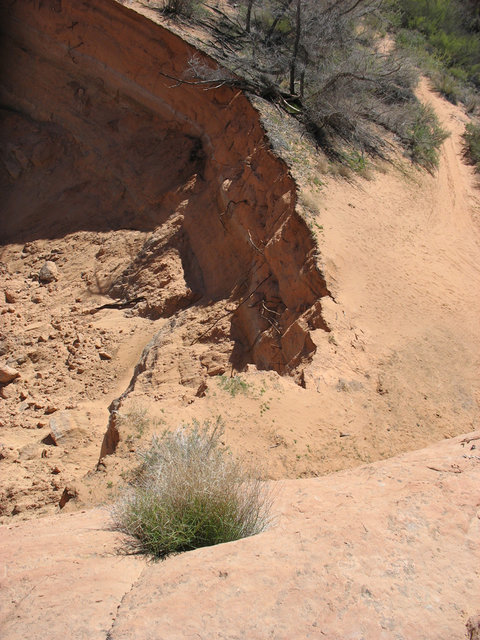
This what it looked like two years ago, I'm sure it is only worse now.

IMG_4763.JPG


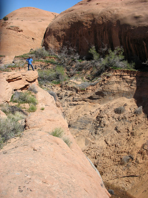
See where the road ends at that drop off? The picture is decieving as to scale - I doubt your winch cable could reach the bottom from there. But, even if it could, here is what you would have to winch yourself up on the other side.


IMG_4765.JPG


I'm positive your winch cable won't reach up here from the bottom :D.

See that cliff below where I'm standing? And that big canyon beneath me? That's the "washout". You used to drive across from picture #1 to picture #2 but now there is a hole more than a hundred feet deep where the road used to be.

Simply put, no way, no day, no how can this "be ran".

- DAA
 
Thanks for the response guys! I was viewing the trail from google earth and have never been there to personally see it. The pictures were very helpful!
 
Although.....this is a great start to a bridge:D
 

Attachments

  • hitr.JPG
    hitr.JPG
    88.6 KB · Views: 24
Maybe with enough man power, shovels, picks, dynamite and maybe even a backhoe it could get fixed... But it would eventually become not passable again after maybe a year or 2 from erosion.I still like the idea of winching down and up lol!! Cable would for sure have to be 150 feet or more?I am willing to give that a shot if and when I get that much cable! Lol!!! Muahaha!!
 
Last edited:
Dave is right. There is no way you will get through there. Corban and I discussed the possibility of doing it on the motorcycles but decided falling into the abyss was not worth it. The only place you could go is fenced and cabled off. It is deeper than Daves pictures show.
 
Why? Just go around. The new route is even fun.
I agree. The new route is very fun and very scenic. You can always go and see the big washout and then backtrack and take the new route. I've done both the old and new routes and both are/were great. No sense in killing/maiming yourself or someone else at the big washout by trying to go around or down and up. Just go view the big washout and then be legal and take the scenic new route.
 
Back
Top