Cedar City RMP

Don B

formerly rebarguy
Location
Southern Utah
Tacoma, what does U4WDA have in the works for this RMP?

I'll be at the scoping meeting in Cedar City. We need to get the local people in Cedar City together and make sure we get the trails in the area included in the inventory. As always, we will be encouraging the 4x4 community to be involved and get their comments in during the ongoing process of this RMP.

The Cedar City scoping meeting is two days before the one in Salt Lake. I'll try to give some suggestions on what to look for before the Salt Lake meeting and hopefully we'll have a crowd there.

They haven't sent a press release out yet, But the first scoping meeting will be in Cedar City on Dec. 7th, second in Beaver on the 8th and the Salt Lake meeting will be Dec. 9th.
 
Last edited:

Don B

formerly rebarguy
Location
Southern Utah
Cedar City BLM to Host Scoping Meetings for Resource Management Planning Effort


Cedar City - The Bureau of Land Management’s (BLM), Cedar City Field Office will host three public scoping meetings to kick off the preparation of the Cedar City Field Office Resource Management Plan (RMP). This new plan will replace the existing land use plans for the Cedar City Field Office which includes the Cedar Beaver Garfield Antimony RMP of 1986 and the Pinyon Management Framework Plan of 1983. In accordance with the National Environmental Policy Act of 1969 as amended and the Federal Land Policy and Management Act of 1976, an Environmental Impact Statement (EIS) will be prepared to support this planning effort.

The Cedar City BLM Field Office is excited to lead the development of a new RMP. The planning area is located in Beaver, Iron, and a small portion of Washington counties, Utah and encompasses approximately 2.1 million acres of public land. Preliminary issues to be addressed in the plan include the following: renewable energy development for geothermal, wind, and solar power; management of site type rights-of-way for renewable energy and other uses; visual resource management; evaluation of potential new Areas of Critical Environmental Concern; Wild and Scenic River recommendations; Off-Highway Vehicle Designations and Special Recreation Management Areas; Wild Horse and Burro management; and fluid minerals management stipulations to protect sensitive resources.

This planning process will seek input from many municipal, county, and state government entities, American Indian Tribes, other federal agencies, and the general public. The Cedar City Field Office will use an interdisciplinary team approach in the preparation of the new plan.

Three scoping meetings will be held to provide the public with opportunities to learn about the plan that is to be developed and to share any information, concerns, or comments they may have. The meetings will be in an open house format and representatives from BLM’s Cedar City Field Office will be available to answer questions. The meetings are scheduled from 5pm to 8pm MST on the following dates at these locations:

Cedar City – Tuesday, December 7, 2010
Festival Hall Convention Center
Room 7
96 North Main
Cedar City, UT 84720

Beaver -Wednesday, December 8, 2010
Beaver Library
Meeting Room
55 West Center Street
Beaver, UT 84713

Salt Lake City – Thursday, December 9, 2010
Salt Lake City Library
Conference Room 4
210 East 400 South
Salt Lake City, UT 84111
The public scoping period began with publication of the Notice of Intent in the Federal Register on September 10, 2010 and ends on December 27, 2010. Written comments may be submitted at the scoping meetings, by letter to the address below, or by e-mail to utccrmp@blm.gov. Please include “Resource Management Plan Cedar City Field Office, Utah and associated Environmental Impact Statement” in your correspondence. All comments must be received on or before the close of business, Monday, December 27, 2010.
 

jackjoh

Jack - KC6NAR
Supporting Member
Location
Riverton, UT
All you Salt Lake guys take notice. All meetings are important but we should have a good turnout in SLC.


Salt Lake City - Thursday, December 9, 2010
Salt Lake City Library, Conference Room 4
210 East 400 South
Salt Lake City, UT 84111
 

cruiseroutfit

Cruizah!
Moderator
Vendor
Location
Sandy, Ut
what time is the meeting in SLC? I am new to the game, so what is a scoping meeting?

The meetings are scheduled from 5pm to 8pm MST

"scoping meetings will be held to provide the public with opportunities to learn about the plan that is to be developed and to share any information, concerns, or comments they may have"
 

Don B

formerly rebarguy
Location
Southern Utah
All the meetings are from 5:00 to 8:00 pm.

The scoping meetings are held near the beginning of the process to develop a new Resource Management Plan. They are looking at input from the public to see what our concerns are. If we are not there to give input, they don't have to consider it.

It is important to let the BLM know who you are and how you want the BLM lands managed in the future. If you use BLM lands or intend to use them for any legitimate pupose you need to let them know. They are required to consider public input and if you make a substancial comment they have to look at it.

It's also extremely important that any roads and trails we want to remain open are on the BLM's inventory at this time so they can be included in the draft alternatives. It's much easier to have them included from the start rather than try to have something added in later.

The meetings in the various Field Offices all seem to have a different format. I'll be at The Cedar City meeting and then try to post up some information and suggestions based on that meeting so the people attending the Salt Lake meeting will have an idea what to look for.
 

Don B

formerly rebarguy
Location
Southern Utah
BLM Scoping Meeting in Cedar City, Dec.7th, 2010

After attending the meeting, my take on it.

Not a big crowd, I think about 50 people over the three hours. I was disappointed by the turnout of 4x4 enthusiasts. I talked with one other, and I know one more was there, but that’s all I saw. I was hoping for more response from the Cedar City area wheelers.

The meeting was the open house type format, where they had their maps and other info on the walls along with BLM employees to answer questions. One item I really liked was they had a large scale map printed out and you could make notes and draw in trails and roads or whatever else you liked, They had comment cards with it that they numbered and you would put the number of the comment card by your notes on the map for reference.

Keith Rigtrup with the BLM was there. He has been promoted to District Planner and will be overseeing this RMP. Keith was in Kanab and was over new RMP there and did a great job. Very thorough and fair and I’m glad he’s involved with this one. Todd Christensen is the Field Office Manager for Cedar City as well as being the District Manager. He’s a good guy to work with. He has a very good opinion of U4WDA from working with them when he was in the Salt Lake area. So, this Field Office has some good people and they will work with us if we give them a chance.

Items of concern I was looking at:

1. Skull Canyon/ Wild West trails and the area they are in. The place is several miles directly west of Cedar City and is shown on the maps as the Swett Hills. The BLM has some of the old roads in this area on their map, but not the trails. I would like to get a proposal into them to make this a SRMA geared towards 4x4 vehicles. Also a possibility would be to have this area made an extension of the Three Peaks Recreation Area. Anyway, these trails need to be GPS’s Asap and given to the BLM so they can be considered in the Draft Alternatives.
2. Three Peaks Recreation Area; I don’t think this is in any danger, but we need to make sure that 4x4’s continue to be included in the management of this area.
3. Open Travel/ Play areas; Three Peaks is not suitable. The BLM staff at the meeting are not aware of any areas that may be suitable. We need input from locals, are there any good places within the Cedar City Field Office that would be suitable?
4. High Desert Trail; The BLM is good with continuing this north through the Cedar City FO area. I know nothing about this. Anyone up to date on the routes they’re looking at including in this trail system?
5. The part that struck me the most looking at the maps was the incredible amount of country and roads waiting to be explored in that part of the world. If only we had the manpower to inventory it all and make sure that nothing valuable is lost. I see this as another huge opportunity lost to us because we don’t have the resources.
 

jackjoh

Jack - KC6NAR
Supporting Member
Location
Riverton, UT
Thanks Don, I am going to try something different. I am going to google earth the area and record all the roads I can find because I am not familiar with the area. I am sure Evan Day and other Rockhounds will be there. I hope all the people that make comments on RME will be there.

Help me here, I thought some of this area was covered in the St. George scoping meeting or is this just the area north of St. George?

I checked the BLM site and see it is the area above the St. George area and mostly west of I15.

Too much area. Don said it best.

Quote:5. The part that struck me the most looking at the maps was the incredible amount of country and roads waiting to be explored in that part of the world. If only we had the manpower to inventory it all and make sure that nothing valuable is lost. I see this as another huge opportunity lost to us because we don’t have the resources.
 
Last edited:

ret32

Active Member
Location
Midvale
I'll be bringing both of my 1:250,000 Utah State Atlases (Benchmark and DeLorme) to tonight's meeting. I'll be using those to verify all those roads are on the inventory. I'll be there at 5:00 and will stay around for awhile in case anybody wants to browse through my atlases.

I will also have printouts of all trails within the area from Peter Massey's Backcountry Adventures Utah book.

Please remember, in addition to making sure a route is on the inventory, now is the time to petition/demand/beg for specific routes to be included on the preferred alternative of the draft RMP. If they don't make it on the preferred alternative, it doesn't matter that they were inventoried, they will be closed anyway.

If somebody's got a map for Skull Canyon/ Wild Wild West, bring it. If somebody's got a GPS track for these trails, share it/bring it/ post it up/ email it/ whatever.

5pm - 8pm
Thursday, December 9, 2010
Salt Lake City Library, Conference Room 4
210 East 400 South
Salt Lake City, UT 84111

Be there!

Thanks,

ret32 (Ron), Utah 4x4 Club Land Use Team
 

jackjoh

Jack - KC6NAR
Supporting Member
Location
Riverton, UT
I was there from 5 to 7 and noticed Dale Bartholomew, Ron Tolman and a few others were there but I didn't get all the names. Ron is super sharp on this map stuff and should be posting when he gets his stuff together. I was impressed with the openness of the BLM people and had some good conversations with a few of them. I noticed they have a very poor opinion of suwa. There opinion seems to be that they should be let alone to do there job without having to put up with lawsuits that we the taxpayer have to pay for because of stupid laws. That brings up a question, if the government has to pay for the lawsuits whether right or wrong, won or lost why was USA-ALL stuck with the lawyers fees for Castle Butte or do they just pay the court costs. We should start a movement that if you lose a case you have to pay court costs.
The area's I posted are: Mountain Springs, North Peak, Paradise Mt., Modena Draw, Summit Mt., Canyon Springs, Fidlers Cy., Table Butte, Antelope Pk., Three Peaks, Swett Hill, Lund, and the High Desert Trail. Could not locate Twisted Forest and Casto Cy..
 

ret32

Active Member
Location
Midvale
I was there from 5 to 7 and noticed Dale ...I noticed they have a very poor opinion of suwa...

If so, not ALL of them do. One key BLM employee spent a good 30 minutes chatting with a SUWA representative like they were old high school friends.

Anyhow, here's my report...


I went to the meeting last night and there was a woeful attendance :(

Including me, there were a total of 6 people who drew comments onto the travel maps. One of them was a client of mine that I brought with me who showed interest at a business related meeting we had a couple of days ago.

At any rate, here's my report...

I stayed at the meeting for the full three hours and spent a significant amount of time talking to various BLM employees and learned the following in the process.

HIGH CONFLICT/ HIGH TRAFFIC AREAS:

As far as potential loss of roads, the told me that they are looking the closest at the "Hurricane Cliffs" area, which basically comprises everything west of I-15. They are also looking closely at the area around Parawan Gap (the hills west of "Parawan Valley" on the attached map). If you have trails in those areas that you know of, please comment on them each individually.

Parawan%20Gap.jpg


LANDS WITH WILDERNESS CHARACTERISTICS:

The BLM has previously identified "Lands with Wilderness Characteristics." These are the pink areas on the ARRWA map below. These areas will have a high likelihood for being designated as "closed to motorized travel." For the most part, those areas are free of any inventoried routes. The exception is the Wah Wah Mountains have a few inventoried routes on the west side and one inventoried route on the north side that penetrates pretty deeply into the boundaries of the "Wah Wah Mountains Lands with Wilderness Characteristics." A road is not a wilderness characteristic! The boundaries of this area should be shrunk to encompass only the roadless area. Another alternative could be to include each of these inventoried routes as a cherry stem into the area. The Granite Mountains or Mineral Mountains "Lands with Wilderness Characteristics" appear to be free of inventoried routes. However, comments should be made that the boundaries of the area should not encompass any of the inventoried roads.

SUWA's ARRWA:

I overheard a BLM employee assure a SUWA representative that the BLM would review the areas from SUWA's proposed America's Red Rock Wilderness Act. They would revisit whether or not any of those areas could qualify to become additional "Lands With Wilderness Characteristics." The striped areas on the below maps are the areas talked about. I didn't have those maps with me at the meeting so I was not able to check for inventoried routes within those boundaries. If you know of any routes within those boundaries, comment on them. Comment in general that roads are not wilderness qualities. No "lands with wilderness qualities" should encompass areas where there are roads. The areas should be shrunk or cherry stemmed to exclude all inventoried roads.

ARRWA%202%20Areas.jpg

ARRWA%20Areas.jpg


SWETT HILLS/WILD WILD WEST/SKULL CANYON:

There is an proactive discussion about this on another forum. Hopefully, somebody will step forward with GPS tracks for Wild Wild West and Skull Canyon soon. I personally promised the BLM I would make sure that happens by the deadline. The BLM claims that they didn't know people even used that area for motorized recreation. Please comment about that area and those trails so they WILL know that people use that area.

SRMA:

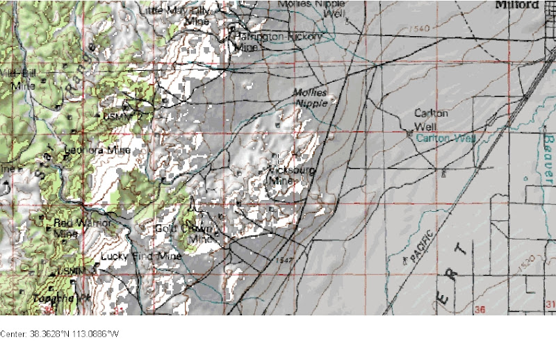
(Special Recreation Management Areas) Don mentioned proposing the Swett Hills as a SRMA for 4x4 use. I discussed this at length with several BLM employees and they seemed eager and willing to consider it. They would really like to see more ideas for SRMA's. Dale, a trails specialist from the Utah State Department of Natural Resources, mentioned to me two areas that contain many 4x4 challenge routes.

One is the East slopes of the Star Range, just southwest from Milford. This is a mining area that contains tons of old 4x4 roads that the locals like to play on.

Another is the Southern end of the Mineral Mountains just north of Minersville. The Lincoln Mine trail heads roughly northeast from Minersville and is highlighted in Peter Massey's Backcountry Adventures Utah Book. Dale told me that there are several other old mining roads in that area that the locals use as 4x4 challenge routes. Remember that the north end of these mountains are already identified as "Lands with Wilderness Characteristics," this boundary should not be expanded to the southern part of this range.

All of these areas: the Swett Hills, Star Range, and South Mineral Mountains seems like ideal places for 4x4 focused SRMA's.

Swett%20Hills.jpg

Star%20Range.jpg

Mineral%20Mountains.jpg


ELEVATION BASED CLOSURES!!!???

Extremely disturbing was a comment made by a BLM employee about how they don't know much about the western half of the planning area. This employee told me that if they don't get comments about these areas, an option is to simply use elevation contours to identify areas that should be closed to motorized use!! :eek::eek::eek: the logic being that at the higher elevations, it is so cold and rugged that people wouldn't want to try and drive up there anyway :blink:. I pointed out areas like Frisco Peak and Mountain Spring Peak (just northwest of Lund) that have popular roads that go right up to the peak of the mountain. In the case of Frisco Peak, it is in Peter Massey's Backcountry Adventures Utah book. I was told I should probably make comments about such areas. There are more. Get out your atlas and start looking and start commenting. That is just simply crazy to consider such a ridiculous method of land planning.

Frisco%20Peak.jpg

Mountain%20Spring%20Peak.jpg


Anyhow, that's all I have. Thanks for reading. Please comment. Please get your spouse to comment. Please find at least one other person that doesn't really care, but should, and get them to comment.
 
Last edited:

cruiseroutfit

Cruizah!
Moderator
Vendor
Location
Sandy, Ut
Thanks for the update Ron & Jack.

There is absolutely no way they will close Frisco peak, its chuck full of repeaters, observation towers and a hang-gliding launch ramp not to mention some mining interests lower on the road. I'm quite concerned that they didn't know anything about this areas as it is likely one of the larger motorized rec areas in their district.

The SUWA Wilderness inclusions are a joke, many of those mountains are chuck full of old mine routes and mine claims, some of which are current mine claims owned by our Gold Rush Expedition and Mojave Underground friends. Corey was spot on when he said having a mine claim could work out to defeat Wilderness, course they will designate it anyway and make him sue to work his claim :rolleyes:

Whats next? Wait until they develop alternatives or are do they have a public input process in place for the scoping period too?
 

Skylinerider

Wandering the desert
Location
Ephraim
I'm quite concerned that they didn't know anything about this areas as it is likely one of the larger motorized rec areas in their district.

Federal Gov't organizations encourage transfers. It's not uncommon to see someone new yearly, (or with National Parks every 6 months). While it may be a good way to get to know more facets of the organization, it hurts in the local knowledge department. I wish they would change this model.
 
Top