yotis 4x4
wheelin=church:)
- Location
- LEHI, UTAH
Any idea how many miles it is roughly?
Yeah it was surprisingly decent for Verizon coverage. Anytime you can see Navajo Mountain, you’ll have service.Any cell service at all?
ThanksYeah it was surprisingly decent for Verizon coverage. Anytime you can see Navajo Mountain, you’ll have service.
There are no signs when you get to the switchback portion that goes down to the lake that says closed to vehicle travel. There are no signs off the Grey Mesa where the Rincon begins that says closed to vehicle travel. I spoke to Glen Canyon officials last year and they said you could go as far as the trail that leads to the lake but again, there are no signs anywhere that it is closed to vehicle travel.Lots of info here. Rincon is closed to vehicle travel.

HITR trail
I’ve been through this trail twice now. Both times in a side x side. This year, I’m thinking of taking a JL Unlimited Rubicon. 100% stock. (ie 33’s). Any thoughts? I know I’ll be fine through Marble Canyon. Getting up and down Grey Mesa, up and down the chute, I’m not sure. I’d also like...www.rme4x4.com
No closed according to Glen Canyon Ranger station. Open to the overlook but said you can't continue and drive down to the lake. This was last year and they have no signs posted that motor vehicles are not allowedThere is zero debate that the managing agency closed it in 1979. The reason they closed it, The ethics of running it in its current status, and the options to get it reopened are where the debate lies.
Just to clarify, you're saying that a GCNRA ranger told you it was open to this point here?No closed according to Glen Canyon Ranger station. Open to the overlook but said you can't continue and drive down to the lake. This was last year and they have no signs posted that motor vehicles are not allowed
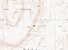
Yes, said you can take the trail until it the portion that leads down to the lake, so to the overlook.Just to clarify, you're saying that a GCNRA ranger told you it was open to this point here?
View attachment 169513
No closed according to Glen Canyon Ranger station. Open to the overlook but said you can't continue and drive down to the lake. This was last year and they have no signs posted that motor vehicles are not allowed
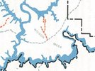
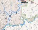
No, it was a ranger I spoke with. There is not one sign at the beginning of the trail on the Grey Mesa or the trail that leads to the lake. Pretty hard for them to claim it is closed to vehicle travel if the person on the trail has no sign to go by. I don't see anything on your maps that show any of the Rincon closed. Just past the overlook at Hole in the Rock that portion on the trail below is closed.Have a name of said person? Are they willing to document that on paper or an email? I'd love for them to legitimize even some of the route, that would be big!
That is contrary to their own maps, their own motorized travel plan and their own recreation travel planner who I spoke at length with.
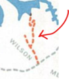
1979 GCNRA map showing the then closure of the Rincon portion
View attachment 169516
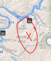
Current GCNRA OHV travel map (note end of HITR is shown as a non-motorized trail & they fail to show the Rincon altogether)
View attachment 169517
No, it was a ranger I spoke with. There is not one sign at the beginning of the trail on the Grey Mesa or the trail that leads to the lake. Pretty hard for them to claim it is closed to vehicle travel if the person on the trail has no sign to go by.
I don't see anything on your maps that show any of the Rincon closed. Just past the overlook at Hole in the Rock that portion on the trail below is closed.
