thering
Member
- Location
- Springville
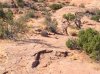
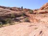
Three weeks ago a bunch of us ventured down to the Hole in the Rock trail. One Jeep Rubicon, my 89 Toyota Pickup, a Jeep Cherokee, and three ATVs. We made it all the way in and out in four days and didn't have any break downs. There are signs of lots of erosion which is making the trail more and more difficult to pass, plus in Lake Canyon the sluff-off is right up to the new bypass. It looks to be very precarious and will probably not be there for very much longer. Enjoy the pics at this url:
http://www.et.byu.edu/~thering/Hole in the Rock/index.html
http://www.et.byu.edu/~thering/Hole in the Rock/index.html