- Location
- Sandy, Ut
Forest Road# 085 is the main (and technically/legally the only) route between Tibble Fork Reservoir and the upper North Fork Drainage including Forest Lake, Poleline Pass, Miner Basin, Mary Ellen Gulch and Lower Major Evans Gulch.
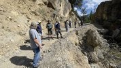
(Washout at 085 Narrows)
At current there is a washout at the 'Narrows' that had the Forest Service worried enough to close the road. It's gated to the south just above Tibble Fork Reservoir (access to Silver Lake Flat Reservoir is preserved) and a new gate installed on the north side just south of the Forest Lake (Shaffer Fork) Trail at the site of Forest City. At current, the only public access to those upper routes is via Poleline Pass.
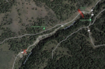
(Washout is red X and the gate is to the right, adjacent to the old Sultana Smelter site at the Forest Lake trail head)
Earlier this week, Preserve & Protect American Fork Canyon (PPAFC) led a group of county officials to this and several other sites in the canyon to survey the damage and discuss solutions. PPAFC Board Member Mark Allen assembled the activity and asked me to lead a group up to the sites and discuss some historical context of the canyon and the routes while there. We were joined by Mike Smith (Utah County Sherriff), Brandon Gordon (Utah County Commissioner), the Utah County Surveyor, the Utah Public Works Director, a Utah County SAR representative and a small group of enthusiasts.
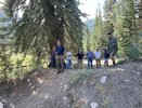
(Looking at the Dutchman washout)
Our first visit was the washout in question along 085. Personal note, it's not as bad as I imagined, in fact I would have zero issues driving any standard 4x4 vehicle through. However, it does have great consequence IF someone went off there AND traffic not respecting the damage could cause further damage and make it harder to fix I suppose. Now, this is a county road on the Utah County road map BUT it is also a Forest Service route. The Forest Service is working to repair this, I'm told that they are waiting on Federal FS in-house engineers to develop a plan/procedure to repair but they have the $$$, just a slow process. I'm told the County has 10-12 local engineering firms they keep on retainer and they could have them start on the repair design ASAP and roll much faster BUT they don't have the budget for this or other repairs without action from their commissioners. Ideal world, we get the Forest Service to fund the County to handle the repair. I don't think that is super likely but I don't know? Either way, nothing is happening in 2023 and we'll be lucky to get the repair kicked off as snow melts next year. It could be this time next year IF things go smooth.
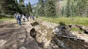
(Washout on Mineral Basin Road)
Next up, we looked at a washout on the Miller Hill 4x4 Trail Route (adopted by ExpeditionUtah ) that has been around for many years. Again, this route is also on the County Road map. We have a few options in play there. Lastly was a major washout section on the Mineral Basin trail, approximately 1/2 mile from the water crossing. This is not preventing passage, the trail is getting routed slightly to the west to avoid the washout. I don't want to put words in the county officials mouths but they sure seemed to indicate all of them were easy fixes, just getting through the red tap and equipment on site is the only issue. If possible, I'd love for them to take a look at a potential trail hazard in Mary Ellen Gulch that could be quickly/easily fixed with some equipment. I'm hoping to get some phone time with FS District Ranger Russ Hanson in the coming days to get an update on his end. Russ wasn't able to join us for this field trip but he and I had some brief message exchanges and he knew we were going to be up the canyon looking at these shared issues.
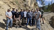
(Our field trip crew)

(Washout at 085 Narrows)
At current there is a washout at the 'Narrows' that had the Forest Service worried enough to close the road. It's gated to the south just above Tibble Fork Reservoir (access to Silver Lake Flat Reservoir is preserved) and a new gate installed on the north side just south of the Forest Lake (Shaffer Fork) Trail at the site of Forest City. At current, the only public access to those upper routes is via Poleline Pass.

(Washout is red X and the gate is to the right, adjacent to the old Sultana Smelter site at the Forest Lake trail head)
Earlier this week, Preserve & Protect American Fork Canyon (PPAFC) led a group of county officials to this and several other sites in the canyon to survey the damage and discuss solutions. PPAFC Board Member Mark Allen assembled the activity and asked me to lead a group up to the sites and discuss some historical context of the canyon and the routes while there. We were joined by Mike Smith (Utah County Sherriff), Brandon Gordon (Utah County Commissioner), the Utah County Surveyor, the Utah Public Works Director, a Utah County SAR representative and a small group of enthusiasts.

(Looking at the Dutchman washout)
Our first visit was the washout in question along 085. Personal note, it's not as bad as I imagined, in fact I would have zero issues driving any standard 4x4 vehicle through. However, it does have great consequence IF someone went off there AND traffic not respecting the damage could cause further damage and make it harder to fix I suppose. Now, this is a county road on the Utah County road map BUT it is also a Forest Service route. The Forest Service is working to repair this, I'm told that they are waiting on Federal FS in-house engineers to develop a plan/procedure to repair but they have the $$$, just a slow process. I'm told the County has 10-12 local engineering firms they keep on retainer and they could have them start on the repair design ASAP and roll much faster BUT they don't have the budget for this or other repairs without action from their commissioners. Ideal world, we get the Forest Service to fund the County to handle the repair. I don't think that is super likely but I don't know? Either way, nothing is happening in 2023 and we'll be lucky to get the repair kicked off as snow melts next year. It could be this time next year IF things go smooth.

(Washout on Mineral Basin Road)
Next up, we looked at a washout on the Miller Hill 4x4 Trail Route (adopted by ExpeditionUtah

(Our field trip crew)
Last edited:
