The backpacking thread

Houndoc

Registered User
Location
Grantsville
Have not done a lot, but a couple summers ago took scouts up Smiths Fork (I think got name right) on a King's Peak attempt. Late July and still stopped by snow. Think I posted a trip report...

Would love to do some southern Utah trips.
 

sixstringsteve

Well-Known Member
Location
UT
When the time comes to get a new bag, I plan on the 20* or 10* zpacks bag with a draft tube. I also like the katabatic quilts, but I toss and turn at night, and I doubt I'll be able to stay inside it.
 

Hardcastle

Active Member
Location
Mantua, UT
I know there are quite a few of you backpackers out there. Where have you been recently? What gear have you been geeking out on? What trips do you have planned? What's on your bucket list?

With all my other hobbies i seem to only go backpacking 2-3 times a year. My wife and I went to Coyote Gulch early spring, a buddy and me went to Abe's Lake in the Uinta's, and I hope to do one more late August or September. I usually keep my trips 2-3 nights although occasionally go on a week long trip. I don't geek out too much on the gear. Keep it simple and lightweight and i'm happy.

I've had a few sketchy moments with bears out in the backcountry but overall my experience has been if you follow the rules and never sleep in the same spot you cooked or prepared meals you'll be safe.
 

sixstringsteve

Well-Known Member
Location
UT
I found another really basic, helpful video for lowering pack weight.

[video=youtube;xNy2b-OXMZg]http://www.youtube.com/watch?v=xNy2b-OXMZg[/video]
 

DAA

Well-Known Member
Saw a couple of bears this weekend. Wish I could have got them to hang around so I could take a picture, but they saw me about the same time I saw them and they instantly ran and disapeared into the thick stuff.

Tried calling one with deer in distress sounds and I "think" it did come in to investigate the call, my buddy Tim heard a rustling in the brush behind us and we found a couple tracks where he heard the noise coming from, but we never got to see it.

Bears are cool :cool:.

- DAA
 

mesha

By endurance we conquer
Location
A.F.
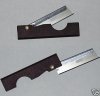
Here is my favorite Ultralight backpacking knife. This is the only knife I took to greenland and it worked great! Cut moleskin, gutted fish, cut cord, cut more moleskin, sliced some pepperoni, cut some more moleskin.

It weighs 7 grams and the plastic part folds out to form a handle. The tip pokes out a little making the point much more useful than a razor blade. Razor blades are cool, but I don't really trust them to not slice my hand open in the dark. I have played around with a bunch of options for the cover, but haven't found the perfect one yet.

Best part? It cost me less than 2 dollars. I bought 5 of them to keep in various packs.

Did I mention it is good at cutting moleskin?
 

Attachments

  • pocket razor 7 grams.jpg
    pocket razor 7 grams.jpg
    15.9 KB · Views: 9

ZUKEYPR

Registered User
Bears are cool :cool:.

- DAA

Until you walk on to your back porch to take the trash out with your head down, hear a snort, only to look up to see a 500 pound black bear 15 feet away from you. Or you go outside to take a dip in the pool and have not one but two cubs doing the backstroke in it and all you can think about is please Momma Bear don't be directly behind me in my path to get back the heck inside.
 

mesha

By endurance we conquer
Location
A.F.
My wife saw a bear right out the tent the other morning. Then she shook the sleep out of her head and realized it was a golden retriever:rofl:
 

sixstringsteve

Well-Known Member
Location
UT
Having not grown up here, I don't know the best hiking trails here. What are some of the best hikes/overnighters/multi-days to do in Utah?
 

sixstringsteve

Well-Known Member
Location
UT
Has anyone done the hike in the Maze that goes from Chimney Rock to the Maze Overlook? Backpacker mag rated it the most dangerous trail in America, and it's got me a little worried. We have GPS and good map/compass skills. I still need to pick up the map, but I'd love some feedback from someone who's hiked it before.
 

mesha

By endurance we conquer
Location
A.F.
Has anyone done the hike in the Maze that goes from Chimney Rock to the Maze Overlook? Backpacker mag rated it the most dangerous trail in America, and it's got me a little worried. We have GPS and good map/compass skills. I still need to pick up the map, but I'd love some feedback from someone who's hiked it before.

I haven't done it, but now I want to.
 

DAA

Well-Known Member
Has anyone done the hike in the Maze that goes from Chimney Rock to the Maze Overlook? Backpacker mag rated it the most dangerous trail in America.

What????? Either we are talking about two completely different trails, or those guys need to quit sniffing glue. I have hiked from Chimney rock to just under the Maze Overlook and back as a day hike. Doing it as a loop, starting from our camp at Chimney Rock, heading down Pictograph fork to check out the Harvest Scene, continuing downcanyon past Brimhall point to where the trail coming down from the Overlook hits the main canyon, then heading back up to camp on the main trail that overlooks Jasper Canyon.

I have also hiked down from the Maze Overlook and hiked Pictograph fork and back up in a few hours.

I did not notice any "danger"? I need to look at the link you posted I guess. We simply can not be talking about the same trail. If we are, I'd like to know what makes it so dangerous. The moki steps maybe? They look way worse than they actually are. But even then, there HAS to be FAR more "dangerous" trails out there?

- DAA
 

sixstringsteve

Well-Known Member
Location
UT
Thanks for posting Dave, that's the exact route I'm thinking. I had the same initial reaction "how can it be that bad?"

I think they're assuming a few things:

1) you've never taken a vehicle to a remote location. You can't just call out and get a helicopter to the nearest hosipital.
2) you're going in the middle of July and it's 110* out

How bad was route-finding along the trail?
 
Last edited:

DAA

Well-Known Member
Route finding was self evident. Just a tiny bit tricky getting down into the canyon, and making sure you are in the right one to begin with, but once you start down into Pictograph fork, you're in a canyon walking downcanyon, pretty simple. Coming back up, the main trail is well travelled and well defined, be pretty hard to get off of it and take a wrong fork accidentally if you are paying even a little bit of attention - and the tail leads right back to Chimney Rock.

Found my old trip report on ExpUT: http://www.expeditionutah.com/forum/showthread.php?t=1967&highlight=harvest+scene

Scanning it real quick, I remembered that I felt like the hike down to Green Mask ruin in Grand Gulch was more dangerous. And the hike we took to find the Perfect Panel, was WAY more dangerous - but that was a lot of offtrail bushwhacking and choosing to risk exposure where it really wasn't necessary. Still though, two other hikes on that one trip I'd rate as far more dangerous than Pictograph fork from Chimney Rock!

- DAA
 
Top